

-
Models 
Enterprise
Inspector
-

FOV – 49.6ºx38.3º (Multispectral)
44.5ºx37x7º (Panchromatic)
-

Resolution – 1456×1088 (1.58MP) [ Multispectral ]
2464×2056 (5.1MP) [ Panchromatic ]
-

Ratio – 4 x 3 (Multispectral)
6 x 5 (Panchromatic)
-

GDS – @120m 7.7cm/px (Multispectral) 3.98cm/px (Panchromatic)
@ 60m 3.85cm/px (Multispectral) 1.99 cm/px (Panchromatic)
-
Middle wave length/ bandwidth
Blue: 475nm / 32nm
Green: 560nm / 27nm
Red: 668nm / 14nm
Red Edge: 717nm / 12nm
NIR: 842nm / 57nm
Panchromatic: 634.5nm / 463nmPixel size 3,45μm
Output bit depth 12bit

1.6 Mpx
120m AGL

We offer a solution that allows us to achieve exceptionally high resolution mapping of land surface and vegetation cover. With twice the spatial resolution and almost 3 times the data recording speed, this is a huge advance in imaging technology from aboard our Prometheus H2 hybrid drone platform.
It is an innovative solution for farmers using the entire growing season for crop production, foresters managing ecosystems with a highly diverse species and age structure, horticulturalists and fruit growers preferring late varieties of fruit and vegetables, livestock scientists, as well as specialists in growing crops on organic substrates. The camera is capable of taking high-resolution images in 5 spectral bands simultaneously required for the study of, among other things:
- detailed mapping of the plant pigment content
- plant health and development stage maps
- vegetation index maps, i.e. NDVI, NDRE, ENDVI, SAVI, MSI, MCARI, GDVI i in.
- maps of land cover by plants
- maps of topsoil moisture
- DSM maps based on a dense point cloud


1.6 MP each
- Blue (475 nm centre, 32 nm bandwidth)
- Green (centre 560 nm, bandwidth 27 nm)
- Red (668 nm centre, 14 nm bandwidth)
- Red edge (717 nm centre, 12 nm bandwidth)
- NIR (842 nm, centre, bandwidth 57 nm)


Each camera kit comes with a reflective panel for field calibration and a DLS2 light sensor to measure irradiance and sun angle. These radiometric calibration tools take into account different weather and lighting conditions, providing more accurate and reliable data that enables time series analysis and comparison of results over time.
With its panchromatic band, the camera enables high-resolution RGB and multispectral images for machine learning applications such as plant counting and advanced vegetation survey applications.

Simultaneous capture of up to six bands, enabling multiple high-resolution outputs such as RGB, crop vigor indices and composites (NDVI, NDRE, CIR), and high-resolution panchromatic.

-
Plant counting
Plant counting algorithms require high-resolution imagery. Camera combines a Panchromatic lens with 5-high-res multispectral lenses enabling high-res RGB and multispectral outputs, allowing plant count even at early growth stages.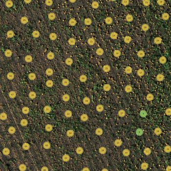
-
Phenotyping
Manually measuring plant characteristics is time-consuming. Band combination enables high-resolution multispectral outputs, allowing the detection of variability at the leaf level. -
Plant health mapping
Cameras high-resolution multispectral outputs allow the generation of indices and composites to see individual chlorophyll levels in the plants and compare over time. -
Fertilizer management
Camera’s high-res and accurate outputs allow easy identification of areas low in nutrients and help monitor the effects of fertilizer applications throughout the season and determine if, when, and where a new application is needed. -
Disease identification
Camera captures a critical part of the light spectrum for studying plants (712–722 nm), called the red edge band. It is in this section of the spectrum that the first signs of stress start to show. Using analytics generated with the red edge band, it is possible to identify disease sooner and act faster to stop the spread. -
Species differentiation
Some differences among species may not be visible to the naked eye. High-res multispectral data allows for species differentiation, weeds included, by highlighting characteristics such as chlorophyll content, vigor, and leaf size -
Advanced crop scouting
High-res multispectral and RGB imagery provides advanced field scouting capabilities. In one flight, it is possible to collect accurate and geotagged information of a problem, making it easy to assess the situation and determine the appropriate intervention. -
High-res 3D point clouds
Cameras’s 5.1 megapixel panchromatic band provides over twice the ground resolution of the industry-standard RedEdge-MX, resulting in 3D point clouds with up to 4 times the point density.


